Project :: Birdcreek
Gold, Copper, Silver, Zinc
Nelson, B.C.
The Bird Creek tenures are located approximately 12 km south of the City of Nelson and 1 km off highway 3A. The mineral tenure group butts up against the western edge of the community of Blewett on its northern boundaries and is contiguous to the claims of Liberty’s Silver Lynx project on its southern boundaries. The Bird Creek project is highly prospective for a deposit of gold, copper, silver and zinc.
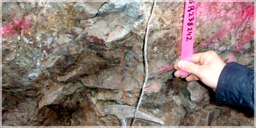
Bird Creek Mineralized Quartz in old Adit
According to Minfile # 082FSW089, the area was first prospected around 1911 and immediately went into production. Very little known exploration was available on the property until 1983. The program in 1983 consisted of reconnaissance mapping, prospecting, rock sampling and stream sediment sampling. A small geochemical soil sampling program of 197 samples and a limited VLF-EM survey were also conducted during this time (Aussant, 1983).
 A 10-hole diamond drilling program was conducted in 1997, at various points throughout the claim block with unknown results. At least four diamond drill holes were drilled with no know target and appear to be parallel to the strike. In 1999, Hobbs, P.Geo, conducted a reconnaissance geochemical survey throughout the whole property with results shown on the grid maps.
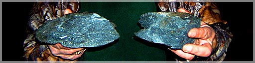
Grid building and another soil geochemical survey were conducted in 2008 by Liberty. Samples taken from the vein in an adit on the property graded 61.7 g/t gold, 89.8 g/t silver and 1% copper over 0.30 meters (Assessment report # 11554). Results of two surface chip samples taken near some old trenches during the 2008 site visit by L. Buss P.Geo are in the chart below:
Bird Creek Chip Samples 2007
| Sample # | Au (g/t) | Ag (g/t) | Cu (%) |
| 203680 | 8.26 | 54.0 | 4.55 |
| 203700 | 1.03 | 17.3 | 1.30 |

Bird Creek North Sample Plan
Mining was conducted on the property intermittently near Bird Creek, on the southern portion from 1911 to 1944 (Minfile # 082FSW089). The main workings included three adits along a flat lying quartz vein. Most, if not all of the mining was concentrated on the high grade core of the zones. The total documented production was 48 tonnes at 58.31 g/t Gold and 51.85 g/t Silver (Minfile # O82FSW089). It is summarized in the table below and all figures are not 43-101 compliant.
Bird Creek Production Summary (Minfile # O82FSW089)
| Year | Tonnes Mined | Mineral | Gms Recovered |
| 1911 | 5 | Au | 156 |
| Ag | 560 | ||
| 1934 | 30 | Au | 1,586 |
| Ag | 1,680 | ||
| 1935 | 9 | Au | 840 |
| Ag | 218 |
The tenure area is situated near the northwestern portion of Bonnington Range of the Selkirk Mountains and overlies the Bird and Snow Water Creeks. Outcrop exposure is limited to road cuts, ridge tops and along creeks.

Bird Creek South Sample Plan
The oldest rocks in the area are a thick succession of nonfossiliferous sediments of the Archibald Formation of the Ymir group (Aussant 1983). This unit is overlain by the volcanic rocks of the Elise Formation and occurs on the western limb of a syncline represented by the Rossland group. A large area of dioritic rocks straddles the Kootenay River and is cut by the late Jurassic Nelson granodiorite.
Numerous dikes of Syenite porphyry, granitic porphyry, quartz porphyry, lamprophyre and aplite penetrate all the rock units in the area (Aussant 1983). Small bodies of biotite monzonite also occur scattered throughout the area. Small scale faults have been noted in the area in the past and are thought to be related to small scale local movements.
The regional metamorphism grades from Greenschist facies in the south to upper amphibolites in the north. In the north, the volcanic rocks have been metamorphosed to pseudo-diorites and the limestones to marble.
The main rock units in this area are the intercalated flows and metasediments of the Archibald Formation which strike northwest and dip towards the southwest (Aussant 1983). The main units were determined by C. Aussant, P.Geol. in 1983 to be moderately metamorphosed in to 4 different units. The assemblages include; brown quartz-biotite schist, green and white banded quartz biotite schist, greenish banded biotite quartz feldspar gneiss and granite gneiss. Many localized pods of the Nelson Batholith intrude all the sediments.
The quartz-mica and quartz-mica-chlorite schist local units contain east striking parallel quartz veins conformable to the regional foliation (Minfile # 082FSW089). The lenses of quartz contain interbanded pyrite and siliceous schist up to 1.0 meter wide and were noted to strike at 085 degrees with a dip of 30 to 45 degrees to the south. Pyrite and chalcopyrite has been reported to occur in various veins in the area. Some free gold was also noted in the oxidized part of the mineralized zones (Minfile #082FSW089). Due to the lack of outcrop exposure, no insitu geological measurements were possible.
Lindsay in 1991, had some petrographic work done on the rock units on the Bird Creek North section of the tenures within the “Moochie Trench” sampling program. Unfortunately the trench sequences of the Moochie, Marco Polo and the King trenches are all on private property and have since been filled in.
 Chip samples from the # 2 Moochie trench graded up to 1.35 % copper and 8.2 g/t silver over 4.0 meters (Lindsay, 1991). The Moochie # 1 trench graded up to 1.82 % copper and 10.0 g/t silver over an unknown distance. The main results of the petrographic work indicated that the Moochie Trench petrography was similar to a copper-gold-calc-alkalic porphyry system, especially in terms of alteration assemblages (Lindsay, 1991).
Hobbs also completed a reconnaissance soil geochemistry project throughout the Bird Creek South area which resulted in both copper and zinc anomalies trending in a northwest - southeast direction. Gold was not assayed for, in the program. However, a small soil geochemistry program for gold was completed around the Fortynine Creek which was not assayed for base metals. No geophysical surveys have been conducted in this section. The lack of outcrop and structure makes ground EM and magnetometer the best methods to locate structures and conductors.
The high tonnage porphyry potential and abundant privately owned surveyed parcels in the North Bird Creek tenure group also dictates that airborne geophysics be employed. The large area of soil mineralization and the history of this mining area, makes it the most likely area to contain or be a part of a porphyry system. Therefore, the preferred geophysical methods would be EM and or conductivity type survey for structure and localized mineral conductors.
Accessibility to the area is quite good with abundant logging roads throughout and average snowfall amounts for the area. Year round access is possible.
Infrastructure in the area is excellent with Blewett less than a kilometer away. A large hydro generation station is immediately north of the property on the Kootney River. Railway and transportation is conveniently local along the highway #3 corridor.