Project :: Orphir Lade
Gold, Silver
Revelstoke, B.C.
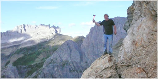
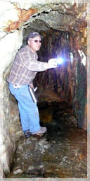
2½ Claim Adit
The Orphir Lade property is located 65 km southeast of the City of Revelstoke on the Kootenay Arc. It is comprised of the Lade and the Orphir claim blocks which are contiguous with the Badshot claims, with all three claim groups held under mining option agreement to Liberty. The Orphir Lade project is primarily a gold project.
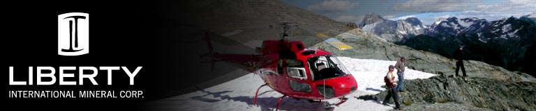
The tenure group is on a northwest trending ridge near the divide of the Marsh Adam Creek and Gainer Creek on the southwestern side of Lade Mountain. Due to the lack of infrastructure and remoteness of the area, access at the present time, is only possible via helicopter. Infrastructure in the area is fairly limited. There is a road/trail within 9 km of this area from Gainer Creek via Trout Lake. No other infrastructure was noted. It can also be reached via a part way trail 18 km east of Trout Lake, “as the crow flies”.
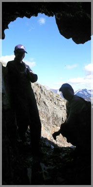
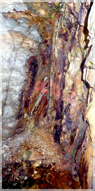
Orphir Altered
Volcanic Schist
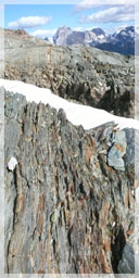
The Orphir Lade tenure package occurs in the Trout Lake stratigraphy of the Kootenay Arc, which is a north to northwest trending belt of Paleozoic and Mesozoic strata The Lade tenures are underlain by the Index Formation, comprised of black and grey phyllite and is overlain by a green phyllite unit and meta-tuff (Minfile # 082KNW032). The entire sequence is overlain by the Lade Limestone. The Lade Limestone is a grey, thick bedded limestone interlayered with cream coloured marble. This unit has been folded into a tight anticline and is overlain by a sequence of green chloritic schist, grey sericite schist and grey micaceous argillite (Minfile # 082KNW032). Quartz boudins elongated parallel to the schistocity are also prevalent throughout the property.
 There are abundant irregular quartz-carbonate veins with localized branch quartz stringers as off chutes. The main mineralized veins are fairly small (<0.3 meters wide) and are documented to contain pyrite, native gold and telluride. Many of the veins at the Orphir are highly oxidized and leached, producing a mixture of honeycomb and massive quartz. Mineralization itself is irregularly distributed with the gangue minerals being ankerite and quartz. (Minfile # 082KNW032).
 "The free gold was found to be much more prevalent around the bismuthenite, but in the main mineralized areas it was found to be more associated with pyrite."
The Lade property was first explored in 1898 and led to the discovery of small veins carrying native gold and telluride, according to Minfile # O82KNW032. It was immediately developed and in 1889, crosscuts of unknown length were driven along the quartz veins. The property was again mined from 1903 to 1904 and consisted of a small tramway and compressors for drilling (Minfile # 082KNW032).
L. Buss PGeo
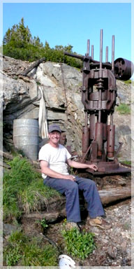
by the 1925 Stamp Mill
Sometime between 1904 and 1922 a small shaft was sunk on the property before the property changed ownership in 1922. A new concentrator and stamp mill were brought onto the site in 1925 and operated for a season.
The property was last worked in 1932, which is the only documented mining data printed (Minfile # 082KNW032).
The total documented production was 12 tonnes for 33.67 g/t Gold.
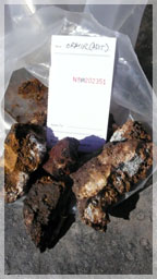
Very little is known about the amount and degree of exploration that has been done on the property since 1898. However, P. Santos, (P. Eng.) did quite a bit of work over the whole Badshot – Lade area and sampled the area around the mine openings in 1988 (GBAR # 18,090). Table below shows some of the 1988 assay values around the lower adit, compared to the samples taken in 2008 by L. Buss for Liberty.
| Sample # | Au (g/t) | Ag (g/t) | |
| 1988 Chip Samples | 21132 | 12.93 | 2.06 |
| 21133 | 7.64 | 4.80 | |
| 21135 | 20.22 | 4.80 | |
| 21147 | 3.26 | 0.69 | |
| 2008 Chip Samples | 203673 | 0.97 | 0.3 |
| 203674 | 3.73 | 0.7 | |
| 202355 | 9.61 | 2.3 | |
| 203675 | 0.03 | 0.6 |
 The Orphir property was explored around the same time as the Lade claim group and also contains small veins carrying native gold and telluride Only minor development/production was mentioned in Minfile # 082KNW032 of an unknown time and/or quantity. The only notes stated “There were numerous open cuts (trenches) scattered over the property and two adits on the Orphir Claim”. “The first adit was 39.6 meters long at 075 degrees and the second was only 15 meters in length at 020 degrees”.
The main information obtained was a regional mapping program by Santos in 1988 who identified numerous steeply dipping, sub-parallel quartz veins throughout both properties.
The mineralization appears to be structurally controlled and as such, numerous geophysical methods can be used to pick the veining patterns and/or lithological contacts in the area but the preferred geophysical method would be EM for structure determination. At 500 meter spacing, approximately 28 km of flying grid would be required to fly the tenures.
The potential for the existence of a large tonnage – low grade gold/silver deposit in the area is good because of the extent of the mineralized host lithology rocks.