Project :: Silver Lynx
Silver, Lead, Zinc, Copper
Nelson, B.C.
 The Silver Lynx Project is highly prospective for a significant polymetallic silver, lead, zinc, copper deposit and is immediately ready to commence drilling with the goal of bringing it to drill indicated resource calculation stage.
Exploration results to date give good indication that a moderate grade – moderate tonnage volcanic exhalative deposit is possible.
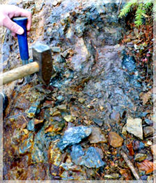
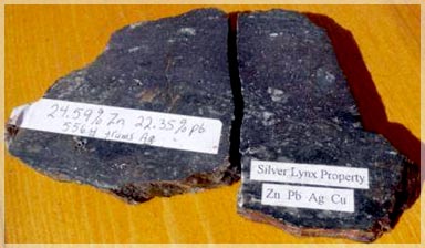
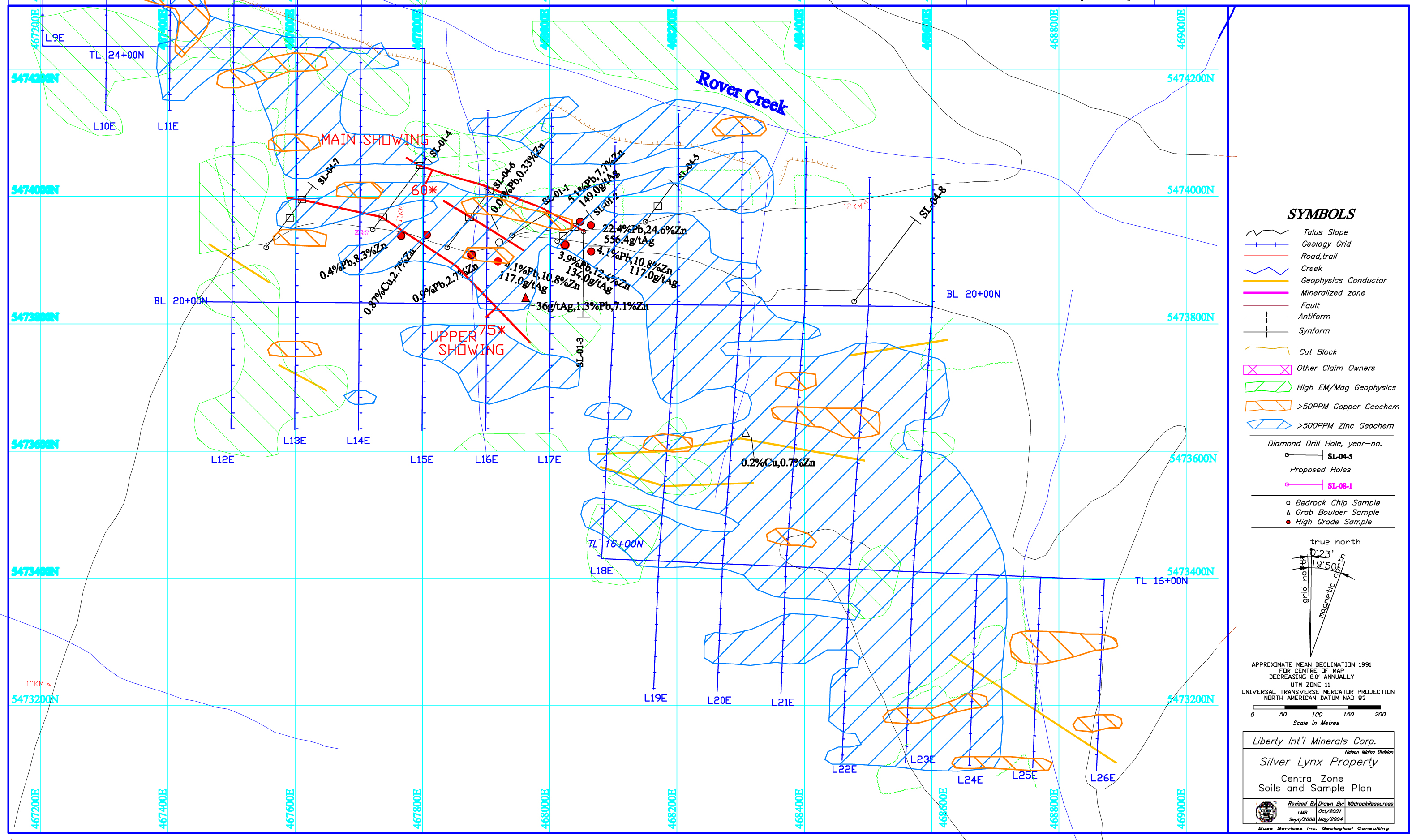
The highest assay from an exploration program conducted in 2000 was from a grab sample from a road cut exposure (~1m x 6m) that assayed 22.35% lead, 24.59% zinc, 556.4 g/t silver and 0.21% copper. (BC MINFILE No 82FSW378)
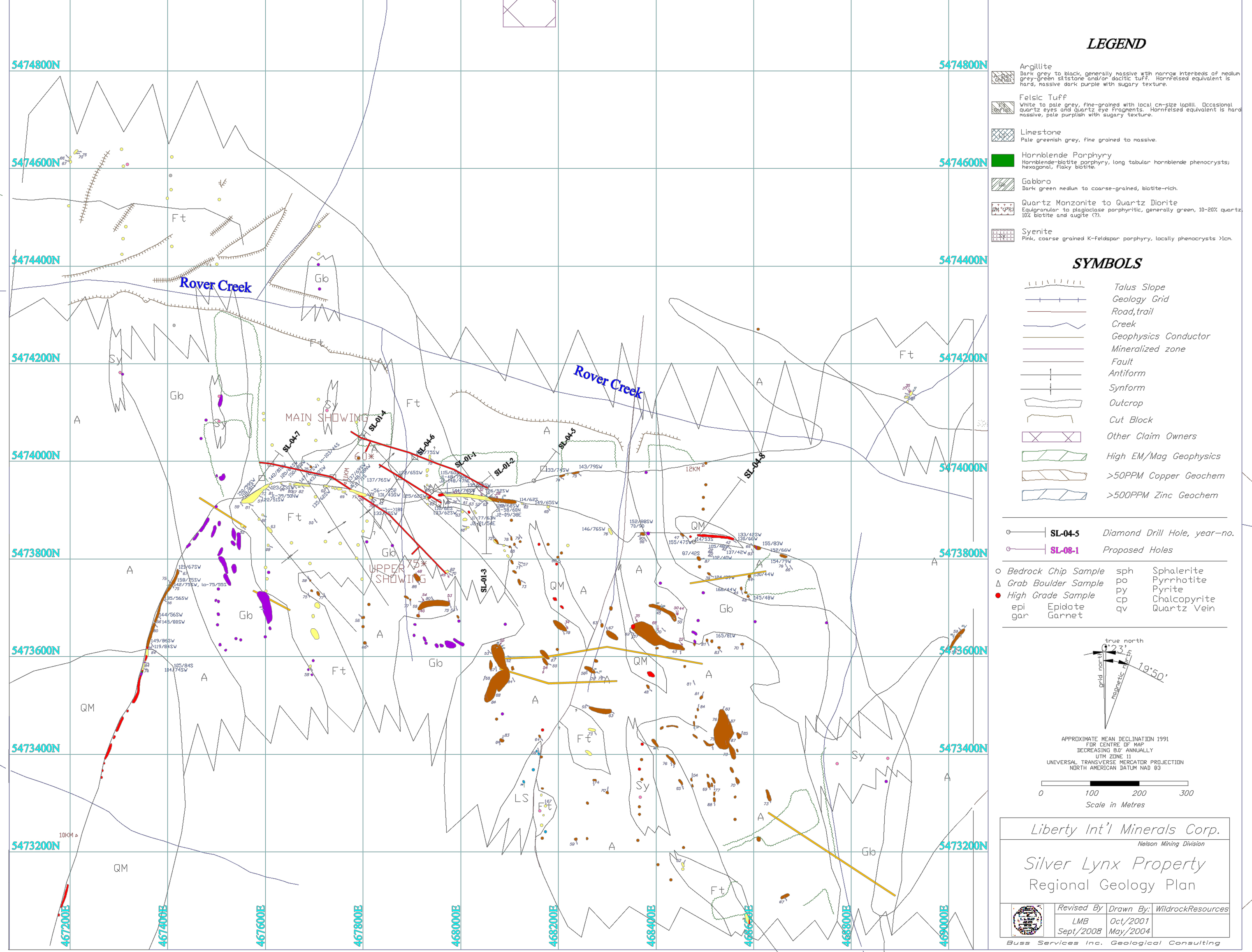
 The Silver Lynx property is situated approximately 20 km south of Nelson and 15 km off highway 3A. The tenures butt up against the southern edge of the Bird Creek Claim Group owned by Liberty. The contiguous properties provide great opportunity for Liberty to follow the mineralization over a long distance, from the main showing in the Silver Lynx South
Like the Bird Creek, the Silver Lynx tenures are underlain by the basinal sedimentary rocks of the Archibald Formation of the Ymir group (Wild, 2004). The mafic volcanic rocks of the Elise Formation of the Rossland Group contact the Ymir rock units east of Rover Creek near Bird Creek. The Rossland Group is intruded by the Middle Jurassic quartz monzonite to granodiorite of the Bonnington Pluton (Wild, 2004). The granitic outcrops are commonly foliated and contain pegmatite lenses that have a northwest – southeast orientation.
The early to middle Jurassic Silver King intrusions occur on the east edge of the Silver Lynx tenures. The lower Jurassic Eagle Creek Complex mafic intrusions are found in the northeast part of the property (Wild, 2004). Hoy and Andrews (1989) mapped a plug of Eocene Coryell intrusions near the centre of the property.
The southeastern half of the property is underlain by fine grain pyritic argillite and the interbedded siltstones of the Ymir group. The Ymir sediments overlie a sequence of phyllitic felsic rocks that were identified to be tuffaceous in nature (Harris, 2001).
The main zones of mineralization appear to be strataform and occur within 10 meters of the sediment-felsic volcanic contact (Wild, 2004). There is a strong foliation to all units which have a northwest strike and a moderate to steep dip southwest. A large southerly plunging antiform also occurs on the property and parallels the strike of the two principle showings.
The northeast limb of the antiform contains a mineralized horizon near the top of the felsic unit (Lower Lynx showing) and repeats the sequence on the southwest limb (Upper Lynx showing). Wild noted a complementary synform and paired synform-antiform to the west of the showings from his mapping project.
The Lower Lynx showing mineralization consists of disseminated to semi-massive phyrrhotite with lesser amounts of blebby, stringer sphalerite, galena and chalcopyrite. The Upper Lynx showing has more sporadic mineralization in the form of blebby, veinlets of sphalerite and disseminated phyrrhotite.
The Silver Lynx property had very little exploration work done on it prior to 2000 when it was prospected and grab sampled with encouraging results.
The grid lines were enlarged in 2001 for a soil geochemistry program in conjunction with geological mapping and a geophysical survey using Magnetometer and EM-VLF.
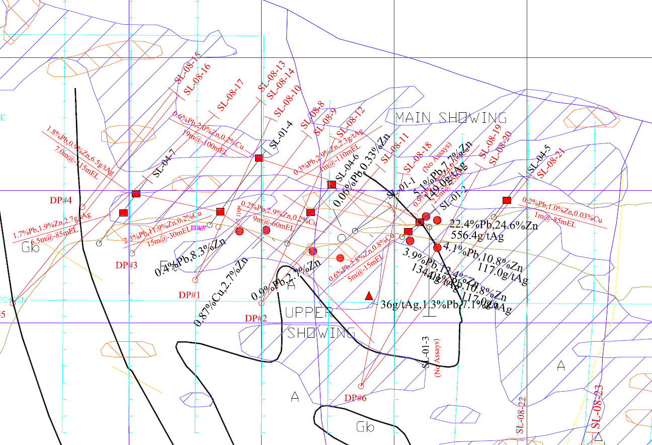
Four diamond drill holes were completed in the fall of 2001 on the Lower Lynx showing with good success. An IP geophysical survey was implemented in the fall of 2003 over the southern half of the property. Based upon the geophysical interpretation, four more holes were drilled on the property in 2004, again with encouraging results. In 2008, a northern geology grid was constructed by Liberty in an area of poor to nil outcrop exposure for a soil geochemical survey.
As already stated, the highest assay from an exploration program conducted in 2000 was from a grab sample from a road cut exposure (~1m x 6m) that assayed 22.35% lead, 24.59% zinc, 556.4 g/t silver and 0.21% copper. (BC MINFILE No 82FSW378_ Cassidy Gold Corp Technical Report 2004).
The best intercept from the two short drill programs (for a total of 7 holes and 1348 meters) conducted by Cassidy Gold Corp in 2001 and 2004 was 0.6 meters with 1.13 % Pb, 6.87% Zn, 0.16% Cu and 42.5 g/t Ag. The table below shows some of the higher diamond drill assay values and are all not 43-101 compliant.
2001-2004, Silver Lynx Drill Results (Wild, 2004)
| Hole # | Length | Pb (%) | Zn (%) | Cu (%) | Ag (g/t) |
| SL-01-01 | 1.00 | 0.44 | 1.45 | 0.02 | 12.0 |
| SL-01-02 | 0.60 | 1.13 | 6.87 | 0.16 | 42.5 |
| SL-01-04 | 1.50 | 0.29 | 1.57 | 0.03 | 11.8 |
| SL-01-05 | 0.30 | 0.28 | 0.86 | 0.20 | 10.3 |
| SL-01-06 | 1.00 | 0.10 | 0.50 | 0.01 | 3.0 |
| SL-01-07 | 1.20 | 1.04 | 0.29 | 0.02 | 34.7 |
The highest of two chip samples collected for Liberty by L. Buss PGeo in August 2008 returned values of 3.9% Pb, 12.4% Zn, 0.38% Cu and 134 g/t Ag. (ECO-TECH Lab _Certificate of Assay AK 2008-1206.
Silver Lynx Chip Samples
| Sample # | Pb (%) | Zn (%) | Cu (%) | Ag (g/t) |
| 203684 | 3.90 | 12.40 | 0.38 | 134.0 |
| 166226 | 0.87 | 2.71 | 0.02 | 15.3 |
According to a BC Government GSC Report written by Trique Hoy, PGeo, the Silver Lynx is “a potential new type of deposit (VMS) in the Rossland Rock Group” indicating a potential low tonnage high-grade deposit.
A thin section petrographic report was completed on three chip samples from the Silver Lynx main showing. One was a host rock unit while the other two were from the mineralized lens. One of the mineralized samples was higher in copper and the other one was deficient in it. Both contained visible lead and zinc. The findings showed that both mineralized samples had the “aspect of a metamorphically recrystallized sulphide rich exhalite of volcanic exhalative origin” (Harris, 2001). It was also found to “free of the excessively fine-grained mutual intergrowths which render many exhalative sulphide deposits very difficult to treat”.
Wild, in his conclusions from 2001, stated that the upper Lynx showing was a fold repetition of the lower showing. The coincident magnetic, VLF, IP, and soil geochemistry, in conjunction with the geological mapping, seemed to support this theory. Therefore, the potential down plunge for a moderate grade – moderate tonnage volcanic exhalative deposit is possible.
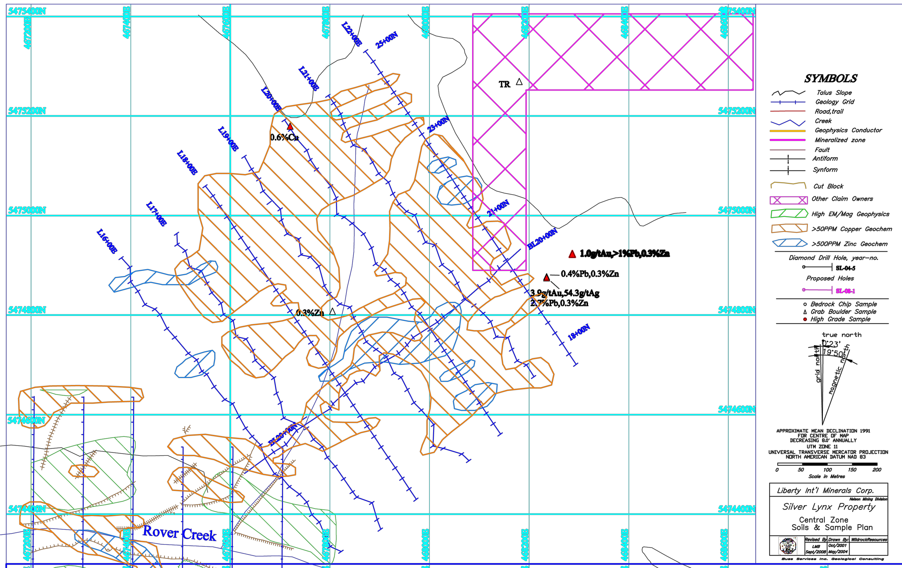
As a comparison to the northern zone, the soil geochemical survey showed a large anomalous zinc signature, greater than 500 ppm. Localized copper anomalies of greater than 50 ppm are coincident with the geophysical IP conductors. Geological mapping and a magnetometer survey have also been completed.
A total of 1,350 meters has been drilled on the mineralized lenses, to an average depth of 150 meters below the outcrop. The drilling identified three main zones at an approximate width of 15 meters. However, none of the previous diamond drilling on the property is 43-101 compliant and as such, is inadmissible, from a resource estimate point of view. The QA/QC methodology and sampling techniques were below industry standard and the drill core lacked markings and/or hole identification.
The Silver Lynx south tenure is the most advanced Canadian property viewed in terms of geological exploration. The previous eight drill holes were scattered along the three lenses with each hole only piercing one lense. It is recommended to drill all three zones together along strike. It is also estimated that 5,000 meters to 10,000 meters of diamond drilling would be required to bring this property into an advanced exploration stage.
Based on reinterpretation of geochemical and geophysical work on the property and additional sampling and mapping by Liberty, the Company has laid out a 14-hole 7200 meter drill program. A drill permit from the BC Ministry of Mines has been issued, the drill pads flagged out, core shack and core racks are all built, previous core hauled in from the field for splitting and sampling, and Liberty is in the process of finalizing the first drill contracts (five companies bidding including two in the local community). Liberty anticipates having drill rigs on site shortly.
It is the intention of Liberty to run two diamond core rigs around the clock, with the possibility of completing the initial 7,200 meter drill program on the Silver Lynx with just over one month’s drilling. The program has been designed to drill through the three parallel mineralized lenses in anticipation of establishing a drill indicated inferred resource calculation on the property. The proposed budget for the initial Silver Lynx drill program including a drill indicated inferred resource calculation, modeling and an NI 43-101 technical report is $1.3 million Canadian.
Due to the varying degrees of exploration on the property, the tenures are split into a north and a south mineralized exploration project. The northern portion consists of a flagged soil grid with minor outcrop. A soil geochemical survey has been completed on the property and showed a large anomalous copper signature, greater than 50 ppm throughout the grid. Localized zinc anomalies of greater than 500 ppm are scattered throughout.
The Silver Lynx North tenure group is ready for the next stage of exploration. Following up on the soil data with ground EM and magnetometer surveys would be the first priority for ground geophysics.
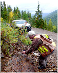
The project is located approximately 20 km south of Nelson BC and 15 km off highway 3A with good access via the numerous logging roads in the area. Infrastructure is excellent with the town of Blewett less than 10 km away, a large hydro generation station immediately north of the property and rail and transportation conveniently located along the Highway #3 corridor.
Approximately 10% of the property is clear cut logged. Accessibility to the area is quite good with numerous logging roads throughout and average snowfall amounts for the area. Year round access is possible with winter road maintenance.
Liberty’s top priority on the Silver Lynx is to drill the main showing in the south to drill indicated resource calculation stage and then systematically trace the mineralization north.